
Creating Property Maps Yield Better Design
Published in APLD Magazine — Design Online — Oct. 2020
At the end of the day, no matter how we assess the customer, frame the history or approach the economics of sustainability, if you are attempting sustainable design you have to look at the natural environment too. And, like we study spaces through pencil and sketch we can be studying the environment the same. Academics, often different from industry, follows a series of design steps that include site analysis, bubble diagrams and other preliminary steps to inform the design program and outcomes. Mining for this data can be cumbersome. And if your clients are anything like mine the idea of them paying for that additional up front work can be a tough sell. Nonetheless they are a critical component to the design process.
I use a number of websites to get started with hopes I save on site time: Beacon gets me concepts on who the neighbors are and the limits to their spaces (https://beacon.schneidercorp.com/). This can help us make some estimates on future development possibilities and more, therefore you’re analyzing a site from a current and future perspective regarding the conditions around your space. Google Earth can at times give you a view of a space that is out of your current season. It can help build perspective on the landscape that surrounds your space too but from an environmental perspective. The USDA has soil data within their NRCS division. https://websoilsurvey.nrcs.usda.gov/app/WebSoilSurvey.aspx. In our studio we often begin our projects this way. We have a goodly amount of undeveloped lands in SW Michigan. Instead of construction or imported soils we are actually working on established earth once farms or other open space. This soils data can be helpful in broad ways. With a little investigation you can pull up in-depth details regarding your types of soil: loam mix, depth of soil types, water table height and more. ArcGIS is another short cut for general topography information (I use the USA Topo map view). Lani and I were at a site a few weeks back that changed 270 elevation feet down a 40 acre hill side. Clearly not something we were going to be measuring with a dumpy. ArcGIS can give us enough data to begin a general dialogue until we determine the needs for more detailed site analysis.
With data like this, as it pertains to your site or scope, you can lay this over site measurements and actually begin to build a decent context of existing features. It doesn’t seem but a few years ago that this exercise was cumbersome and on simple trace paper. Now we do this in CAD, scaling our soils maps, topo maps, bordering spaces or buildings etc. From here a simple analysis can be done in only a few minutes. Things we look for are: views (in and out – good and bad), weather patterns (winds, sun, shade etc), slopes, traffic (current and expected – foot and auto), noise or other obstacles, relevant special studies (human or ecological), soil conditions (type, wet, dry etc), setbacks, utilities and any other unique pieces to a project.
Not all of these are relevant every time and not all are done in scaled overhead view. I had one particularly difficult client needing access to the river their property bordered. They were convinced that filling in the wetland between the bluff and river would ‘clean up’ the place and make easy dry accessibility where grandkids could run and play. For obvious reasons I was discouraging a sweeping approach like that but wasn’t making great headway swaying their perspective. Eventually spring came and I was able to snap a few pictures, stitch them together and sketch simple plant colonies and ecological patterns over the picture. Often this site analysis is never seen by the client. But, at times it greatly helps them understand we are giving informed solutions not just creative ideas. You can see from the attached picture it was an elementary analysis that only took a few minutes to produce. But it helped build better understanding for the client and ultimately encouraged a reasonable dock location.

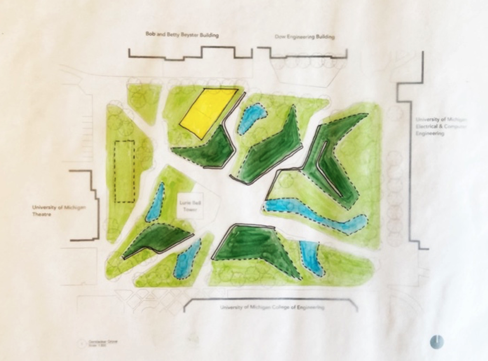
This other series of plan view drawings of Gerstacker Grove is a project our son is currently working on in grad school. One is a snapshot of traffic patterns, split by volume of pedestrian movement. The other is a spatial study separating spaces into a few basic elements. With these you will notice them being produced through a few different media, both CAD and hand drawing. I think when using studies to inform design we make them as simple as we can. This is because they are tools for us as designers, a tool to produce informed design, a tool to create sustainable long-term solutions.


I’ve read that when Chinese landscape designers took on a new project hundreds of years ago, they moved to the property for a minimum of a week. They would watch the space throughout the day and night, observing many of these same elements. They would spend time sketching observations and taking notes on what they sensed, felt and saw. Not so sustainable in a time where we are all being pulled in a million directions. Covid has swamped many of us with unreasonable workloads. Lani and I, as well as our close family, are all sounding like broken records, working longer days and every weekend. I’m not sure if the idea of moving to a property for a week of sitting outside sounds idyllic or just crazy. Times have changed but the information needed for good design hasn’t. We have tools in our pouch to gain good data. Those tools are not only helping us create informed sustainable designs but possibly sustainable schedules in a time of insanity. Because at the end of the day as landscape designers we provide natural and beautiful solutions to customers that profoundly shape our environment and future. Our profession has been around as long as history has kept record. With changes in climate and overcrowding, demand for what we offer is increasing at an unbelievable pace. And of all things we need to sustain for a better future it’s us, our sanity, our product.